Abandoned Communities ..... Woodend
In the early eighteenth century Woodend was a hamlet half a mile south of the village of Awre. It lay very close to the west bank of the Severn estuary.
Maps and aerial photographs of the area today can be seen on the Bing Maps website.
Later I will talk about the way of life experienced by the people of Woodend and describe how their dwellings were destroyed. First, however, we will consider some of the important physical features of the Severn Estuary as these formed the context of much of the local lifestyle and also gave rise to the destruction of the hamlet.
Large quantities of silt are transported by the water of the estuary. Some of it, comprising sand and organic material, comes from the rivers that feed into the estuary. In addition a great deal of sand enters the estuary from the sea. Much of the land adjacent to the estuary has been formed from sediment deposited along the shoreline. Parts of Somerset, the coastal area either side of Newport, and a large part of the land covered by the city of Cardiff were created in this way. Further up the estuary the land between Awre and Awre Point, the Awre promontory, also consists of alluvial deposits.
Since the Roman occupation of Britain attempts have been made to take advantage of the accumulation of sediment by claiming new areas of land. Reclaimed land is drained by ditches and may be protected on the seaward side by embankments. It is often very fertile and suitable for crop production. Otherwise it has been used to provide pasture for livestock. Once the land has become stable houses and other buildings have sometimes been constructed on it.
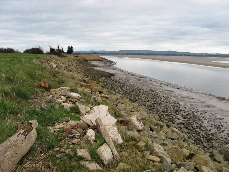
The transport of silt also means that features within the estuary are continually changing. The shape and contours of large sandbanks and mudflats keep shifting, while smaller sandbanks may appear and then disappear. Channels carrying larger and more rapid flows of water may change their position. It is believed that close to the southern shore of the Awre promontory a major new channel was formed in the thirteenth century. That channel is clearly shown on maps of the eighteenth and nineteenth century, and can still be seen today (see map and photograph on the left).
The Severn estuary is tidal as far north as Gloucester, where two weirs prevent the further advance of incoming tides. Tides entering the estuary have enormous energy, and the funnelling effect of the Bristol Channel as it narrows and becomes more shallow creates an exceptionally high inter-tidal range. At Avonmouth the average spring tide is 12.3 metres, while ranges of 14 metres or so are occasionally recorded. North of Awre Point, where the estuary undergoes further narrowing, the front edge of the incoming tide is often visible, and audible, in a phenomenon known as the Severn bore.
For more on the Severn bore read Fred Rowbotham, The Severn Bore, 3rd edition, David & Charles, 1983, or go to www.severn-bore.co.uk .
Maps and aerial photographs of the area today can be seen on the Bing Maps website.
Later I will talk about the way of life experienced by the people of Woodend and describe how their dwellings were destroyed. First, however, we will consider some of the important physical features of the Severn Estuary as these formed the context of much of the local lifestyle and also gave rise to the destruction of the hamlet.
Large quantities of silt are transported by the water of the estuary. Some of it, comprising sand and organic material, comes from the rivers that feed into the estuary. In addition a great deal of sand enters the estuary from the sea. Much of the land adjacent to the estuary has been formed from sediment deposited along the shoreline. Parts of Somerset, the coastal area either side of Newport, and a large part of the land covered by the city of Cardiff were created in this way. Further up the estuary the land between Awre and Awre Point, the Awre promontory, also consists of alluvial deposits.
Since the Roman occupation of Britain attempts have been made to take advantage of the accumulation of sediment by claiming new areas of land. Reclaimed land is drained by ditches and may be protected on the seaward side by embankments. It is often very fertile and suitable for crop production. Otherwise it has been used to provide pasture for livestock. Once the land has become stable houses and other buildings have sometimes been constructed on it.
The transport of silt also means that features within the estuary are continually changing. The shape and contours of large sandbanks and mudflats keep shifting, while smaller sandbanks may appear and then disappear. Channels carrying larger and more rapid flows of water may change their position. It is believed that close to the southern shore of the Awre promontory a major new channel was formed in the thirteenth century. That channel is clearly shown on maps of the eighteenth and nineteenth century, and can still be seen today (see map and photograph on the left).
The Severn estuary is tidal as far north as Gloucester, where two weirs prevent the further advance of incoming tides. Tides entering the estuary have enormous energy, and the funnelling effect of the Bristol Channel as it narrows and becomes more shallow creates an exceptionally high inter-
For more on the Severn bore read Fred Rowbotham, The Severn Bore, 3rd edition, David & Charles, 1983, or go to www.severn-
One

Part of Bryant’s map of Gloucester, 1824
The shoreline at Woodend, looking north, soon after the tide has begun to come in
The images of Bryant’s map and the records on the following pages are produced with the permission of Gloucestershire Archives.