Abandoned Communities ..... Wharram Percy
Only about 6% of the total area has been excavated, and general statements about Wharram Percy therefore have to be regarded as provisional. Each dwelling took the form of a longhouse comprising an inner room used for sleeping or as a dairy, a living room with a central hearth, a cross passage, and beyond it a room used as a cattle byre or for other farming purposes. The longhouses were of cruck construction. Crucks were pairs of large curved timbers that formed the frame of the house and supported the roof. The walls, which were not load bearing, were made of flimsy materials and had to be renewed from time to time.
Objects found during excavation of the houses have included pivot stones, hinges, and door keys. They indicate that the doors were of solid construction and that residents were sufficiently concerned about security that doors were fitted with locks.
Most plots would have had outbuildings for storage or to carry on a trade such as baking or carpentry. Beyond the plots were the open fields that lay within the boundaries of Wharram Percy. They were farmed on a communal basis, and used for livestock as well as crop production.
It has been possible to make out roads and trackways, as shown on the diagram on the left. Three roads ran from Wharram Percy to other settlements, road R1 to the market town of Malton, R2 to Towthorpe (another deserted village), and R3 to Thixendale. The tracks led from one part of the village to another or out into the fields.
There were two manor houses in the village, though the one in the centre of the village was demolished soon after 1250. The northern manor house was much grander. It has not been excavated, but the earthworks, supplemented by photographs from the air, are clear enough to allow informed guesses about its layout and the functions of its various buildings.
A conjectural reconstruction of the manor as it may have appeared in the thirteenth century and an interpretative plan of the area can be seen in Beresford and Hurst, op cit, p23. The plan is reproduced at the foot of this page.
The central part of the manor complex consisted of living accommodation and space for farming activities. To the west lay a large barn, possibly used for storing grain. Beresford and Hurst suggest that the space between the main house and the barn may have been a private garden, well protected from the prevailing westerly winds by the barn. On the south side there was a yard with a grain-drying kiln. West of the main buildings there is evidence of two larger structures. As they are too big to have been covered with a roof they were probably used as livestock pens.
The second manor house was discovered unexpectedly in an area previously thought to have been occupied by ordinary houses. In the thirteenth century it was the home of the Chamberlain family, but in 1254 Peter de Percy, the owner of the northern manor, acquired its manorial rights and the two manors were amalgamated into one.
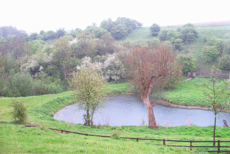
Documentary records show that in the early thirteenth century there were two mills. They are assumed to be water mills used to grind corn into flour. When the two manors were amalgamated the southern mill probably became redundant. In the fourteenth century a much larger dam was constructed, probably with the intention of retaining a fishpond. The pond continued to be used for various purposes until the early twentieth century, its last function being to wash sheep. After it had been excavated and examined by Beresford and Hurst the dam was restored and the pond recreated.
Objects found during excavation of the houses have included pivot stones, hinges, and door keys. They indicate that the doors were of solid construction and that residents were sufficiently concerned about security that doors were fitted with locks.
Most plots would have had outbuildings for storage or to carry on a trade such as baking or carpentry. Beyond the plots were the open fields that lay within the boundaries of Wharram Percy. They were farmed on a communal basis, and used for livestock as well as crop production.
It has been possible to make out roads and trackways, as shown on the diagram on the left. Three roads ran from Wharram Percy to other settlements, road R1 to the market town of Malton, R2 to Towthorpe (another deserted village), and R3 to Thixendale. The tracks led from one part of the village to another or out into the fields.
There were two manor houses in the village, though the one in the centre of the village was demolished soon after 1250. The northern manor house was much grander. It has not been excavated, but the earthworks, supplemented by photographs from the air, are clear enough to allow informed guesses about its layout and the functions of its various buildings.
A conjectural reconstruction of the manor as it may have appeared in the thirteenth century and an interpretative plan of the area can be seen in Beresford and Hurst, op cit, p23. The plan is reproduced at the foot of this page.
The central part of the manor complex consisted of living accommodation and space for farming activities. To the west lay a large barn, possibly used for storing grain. Beresford and Hurst suggest that the space between the main house and the barn may have been a private garden, well protected from the prevailing westerly winds by the barn. On the south side there was a yard with a grain-
The second manor house was discovered unexpectedly in an area previously thought to have been occupied by ordinary houses. In the thirteenth century it was the home of the Chamberlain family, but in 1254 Peter de Percy, the owner of the northern manor, acquired its manorial rights and the two manors were amalgamated into one.
Documentary records show that in the early thirteenth century there were two mills. They are assumed to be water mills used to grind corn into flour. When the two manors were amalgamated the southern mill probably became redundant. In the fourteenth century a much larger dam was constructed, probably with the intention of retaining a fishpond. The pond continued to be used for various purposes until the early twentieth century, its last function being to wash sheep. After it had been excavated and examined by Beresford and Hurst the dam was restored and the pond recreated.
Two
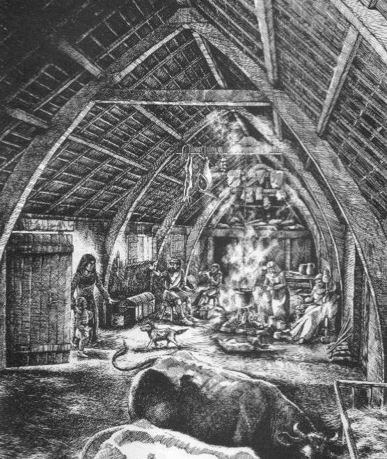
Imaginative interior of a cruck house
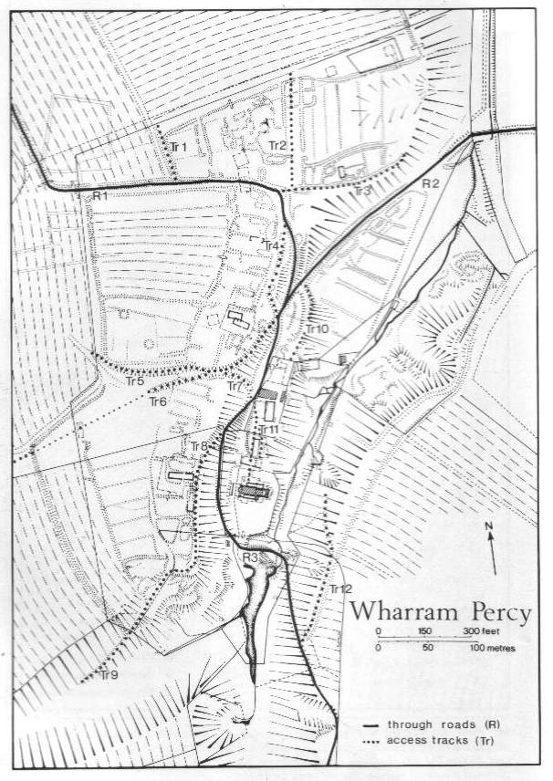
Roads and tracks
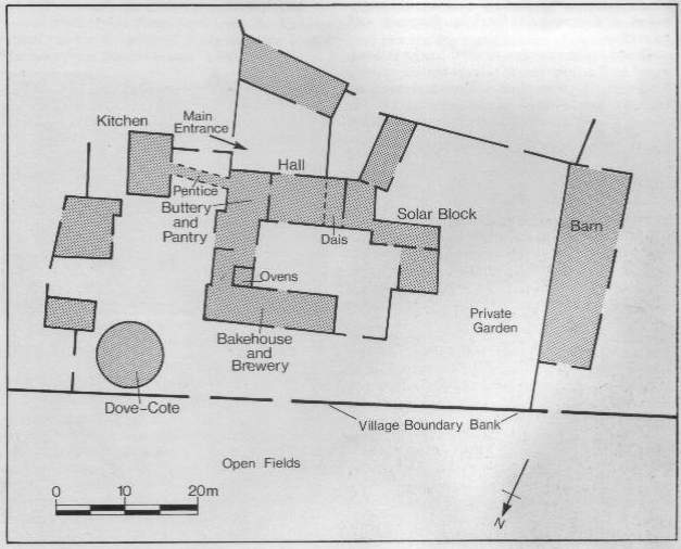
Plan of the north manor house
The dam and fishpond