Abandoned Communities ..... Grahamston
Another enterprise popular in the early nineteenth century was cock fighting. When Hope Street was extended south to join Argyle Street around 1830 many small trades occupied premises on either side of the road. The trades on the west side of Hope Street included a large horse-shoeing and veterinary establishment. According to Robert Lindsay numbers of well dressed people could be seen going in and out of this place, but also others of less reputable appearance. The general public were not aware that these people went there to attend cock fighting sessions in a secret cockpit created at the rear of the premises.
As it happens the cockpit may not have been as secret as Robert Lindsay asserts. It is also described by James Cleland in the New Statistical Account of Scotland. Cleland tells us that the cockpit had seating for 280 persons and also had accommodation for the judges, handlers, and feeders. Cleland confirms Robert Lindsay's view of the varied social status of those attending the cockpit. He states that the company frequenting the cockpit did not belong to the “exclusives”. On the contrary you might find all grades from the senator to the journeyman butcher.
Grahamston started to lose its separate identity in 1830. In that year the Glasgow Royalty Extension Act was passed by parliament. The municipal boundaries of the city were extended by adding the Lands of Blythswood and other adjacent lands. I am not sure whether Grahamston would still have been regarded as part of the Lands of Blythswood, the estate from which it had been feued by John Graham in 1709. It may have been part of the adjacent lands. But from 1830 Grahamston and the larger area to the north west became part of Glasgow.
The process of annexation began in 1828 when a large group of the Feuers and Inhabitants of Blythswood presented an application to the Glasgow council. A prominent motive was the need for an adequate police force in the area. There was, however, a good deal of opposition. The MP for Glasgow, Archibald Campbell, who may have been the owner of the Blythswood estate at the time, had several objections. Some residents of Blythswood issued a pamphlet objecting to the proposals as they had retired from the city to enjoy the quiet and salubrity of the atmosphere of Blythswood. The Corporation of Weavers and the Corporation of Bakers expressed opposition. There was extensive discussion about the extent to which the inhabitants of the annexed area should become liable to the duties and taxes in force in Glasgow. But the Magistrates and Council of the city were strongly in favour of the annexation, and on 6 July 1830 the council recorded that it had been passed by Parliament.
You can follow the process of annexation in detail in the minutes of Glasgow Council for 1828 to 1830. They can be read in the Mitchell Library.
By 1853 all the land in Grahamston had been built upon. We know that from a magnificent drawing of an imagined aerial view of Glasgow kept in the People's Palace. Part of the drawing is reproduced on the left, with a dotted line marking Argyle Street, Hope Street, Gordon Street, and Union Street. Alston Street, the main street running through the centre of Grahamston, can also be seen. While the number of shops and businesses steadily increased the resident population began to decline. Having reached 1924 in 1841 the population fell to 575 in 1871.
The period between 1841 and 1871 was of course also a time when the railway system expanded rapidly. Three rival railway companies operated trains into Glasgow and they competed for the most favourable land for new routes and the construction of stations. I will not attempt to summarise the process of land acquisition and building, nor the sometimes bizarre consequences of the competition between the companies. There is an account of these things in Norrie Gilliland's book. But one of the companies, the Caledonian Railway Company, decided that Grahamston would form a suitable location for its main terminus in Glasgow. Parliamentary authority was obtained in 1873 for the station and associated developments including a major new bridge over the River Clyde. Most of Grahamston was demolished, and Glasgow Central Station was opened on 1 August 1879.
A large number of people must have been displaced. I would like to know more about any assistance they received as they made arrangements to find new accommodation. I would like to know how they coped with the enforced move and what happened to them afterwards. All I will do is mention some of the families who lived for at least ten years in the Grahamston area and would have found themselves obliged to leave. I will select some of the families that lived in Alston Street at the time of the 1861 census and were still there in 1871. Many of these families lived in tenements occupied by up to a dozen households.
At 35 Alston Street, for example, one family comprised Andrew McNeil, a blacksmith aged 48, with his wife and two sons, Andrew a carter's boy aged 14, and John a scholar aged 5. At the same address lived John McCairns, a marble polisher aged 56, with his wife Jannet and their five daughters aged between 13 and 21. The oldest daughter, Hellen, was working as a silk draper. Another family in that tenement were James Urie, a brass finisher aged 37, his wife Jannet working as a loppet cutter, and their son and two daughters.
At 41 Alston Street the head of household in 1861 was Peter Scott, a carter aged 71. His wife Margaret aged 48 lived with him, together with their daughters aged 20 and 18 and their son, Thomas, a cooper aged 16. In 1871 the head of household at that address was Margaret Scott, and I assume Peter died in the intervening period.
Another family that seem to have lost the father in the period between the two censuses were the Georges at 53. In 1861 the head of household was William George, a cooper aged 48. His wife Jane lived with him, together with their daughter of 9 and James Stewart, a son of Jane aged 16 and working as a boxmaker. By 1871 Jane George had become the head of household, though without a listed occupation.
Four
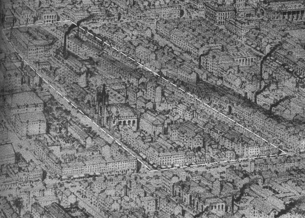
An aerial view of Grahamston and the surrounding districts in 1853.
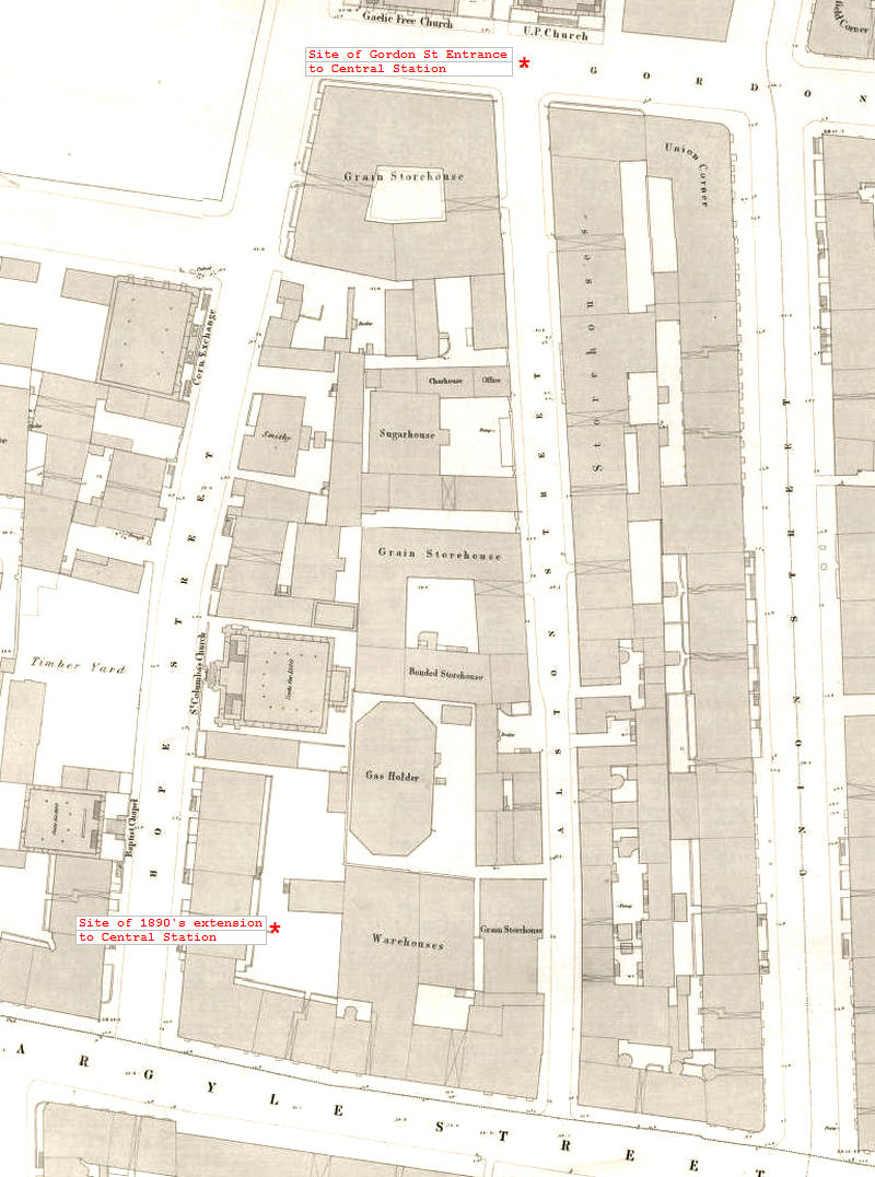
A map of Grahamston from about the same time as the aerial view above.
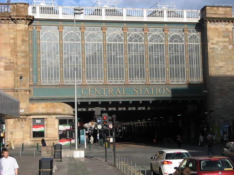
Part of Glasgow Central Station, showing the bridge over Argyle Street. Soon after the station was built this bridge became known as the Heilanman’s Umbrella as it was a popular meeting place for people from the Highlands.