Abandoned Communities ..... Ayrshire
We will now travel across Ayrshire to the western end of the coal field. As coal mining developed rapidly during the nineteenth century housing was provided close to the pits. In some case the housing estates grew into permanent villages and towns such as Annbank and Mossblown. But many of the smaller settlements were eventually demolished.
Four such smaller settlements were located within a couple of miles of Annbank. They were Burnbrae, Craighall, Tarholm, and Woodside.
Burnbrae, at OS NS 413232, was the oldest of these hamlets. It consisted of three rows of housing believed to have been built in the first half of the eighteenth century. According to a report in the Glasgow Herald, it was occupied in 1875 by 15 or 16 families. The roofs of the dwellings were made out of slates and thatch. The ceilings were low, the floors were of stone, and the windows were small. In the summer the houses were liable to invasion by bugs, “not singly, but in battalions.” The door steps were below the level of the street, and as a result water would often flow into the houses during heavy rain. There were two sources of water, a spring well that gave “sparingly in winter, and not at all in summer”, and a field drain from which the water was likely to be brown in colour.
Glasgow Herald, 26 January 1875.
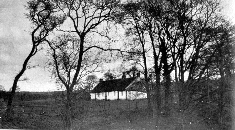
A photograph of Burnbrae was displayed in an exhibition in Glasgow in 1901, winning the top award. Reproduced on the left, it shows the street, now the B742, in the foreground, Burnbrae on the other side of the road, part of Crawfordston Farm beyond it, and the Enterkine Viaduct in the distance.
The last few people departed from Burnbrae during the 1920s. On the valuation roll for Ayrshire 1925-26 ten dwellings are listed, but three of them are described as uninhabitable. In the seven occupied dwellings five of the heads of household were colliers, one a brushman, and one a drawer. All 10 dwellings were uninhabitable when the valuation roll for 1929-30 was compiled. They had in fact been burnt down in December 1928, an event reported in the Manchester Guardian on 13 December 1928.
Craighall, at OS 392223, and Tarholm, at OS 395222, lay not far from each other on opposite sides of the River Ayr, about a mile south west of Annbank. Tarholm consisted of just two rows of thatched houses on either side of what is now the B744. Tarholm Nursery now occupies the site of the Big Row, while the Wee Row has been replaced by a single house called Stanalane. Tarholm is thought to have derived its name from the fact that tar was made there early in the eighteenth century. Produced by a method devised by Archibald Cochrane, 3rd Earl of Dundonand, the tar was used by the Royal Navy as a wood preservative on ships’ bottoms.
A nasty accident occurred at Tarholm coal works on 15 January 1846. Three boys “belonging to the works” were amusing themselves, during an interval of labour, at the bottom of the shaft, when a section of rock about 10 fathoms from the bottom gave way. One of the boys was struck on the head and died half an hour later. According to the newspaper report of the incident no blame could be attached to the manager, Mr Drinnan, as he had repeatedly warned the boys of the danger of standing in the bottom of the shaft.
Glasgow Herald, 26 January 1846
Craighall lay on a small hill overlooking a sharp bend in the river. It is believed that before being converted into housing its buildings were used as stables by the cavalry stationed at Barrackhall, a little further west. By the time of the 1841 census 20 familes lived there.
Most of the houses in Craighall were demolished in 1933, but two were left standing. They are still there today, now used as a garage and storage space associated with the new house of Craighall.
Four such smaller settlements were located within a couple of miles of Annbank. They were Burnbrae, Craighall, Tarholm, and Woodside.
Burnbrae, at OS NS 413232, was the oldest of these hamlets. It consisted of three rows of housing believed to have been built in the first half of the eighteenth century. According to a report in the Glasgow Herald, it was occupied in 1875 by 15 or 16 families. The roofs of the dwellings were made out of slates and thatch. The ceilings were low, the floors were of stone, and the windows were small. In the summer the houses were liable to invasion by bugs, “not singly, but in battalions.” The door steps were below the level of the street, and as a result water would often flow into the houses during heavy rain. There were two sources of water, a spring well that gave “sparingly in winter, and not at all in summer”, and a field drain from which the water was likely to be brown in colour.
Glasgow Herald, 26 January 1875.
A photograph of Burnbrae was displayed in an exhibition in Glasgow in 1901, winning the top award. Reproduced on the left, it shows the street, now the B742, in the foreground, Burnbrae on the other side of the road, part of Crawfordston Farm beyond it, and the Enterkine Viaduct in the distance.
The last few people departed from Burnbrae during the 1920s. On the valuation roll for Ayrshire 1925-
Craighall, at OS 392223, and Tarholm, at OS 395222, lay not far from each other on opposite sides of the River Ayr, about a mile south west of Annbank. Tarholm consisted of just two rows of thatched houses on either side of what is now the B744. Tarholm Nursery now occupies the site of the Big Row, while the Wee Row has been replaced by a single house called Stanalane. Tarholm is thought to have derived its name from the fact that tar was made there early in the eighteenth century. Produced by a method devised by Archibald Cochrane, 3rd Earl of Dundonand, the tar was used by the Royal Navy as a wood preservative on ships’ bottoms.
A nasty accident occurred at Tarholm coal works on 15 January 1846. Three boys “belonging to the works” were amusing themselves, during an interval of labour, at the bottom of the shaft, when a section of rock about 10 fathoms from the bottom gave way. One of the boys was struck on the head and died half an hour later. According to the newspaper report of the incident no blame could be attached to the manager, Mr Drinnan, as he had repeatedly warned the boys of the danger of standing in the bottom of the shaft.
Glasgow Herald, 26 January 1846
Craighall lay on a small hill overlooking a sharp bend in the river. It is believed that before being converted into housing its buildings were used as stables by the cavalry stationed at Barrackhall, a little further west. By the time of the 1841 census 20 familes lived there.
Most of the houses in Craighall were demolished in 1933, but two were left standing. They are still there today, now used as a garage and storage space associated with the new house of Craighall.
Five
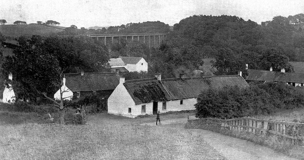
Burnbrae in 1901
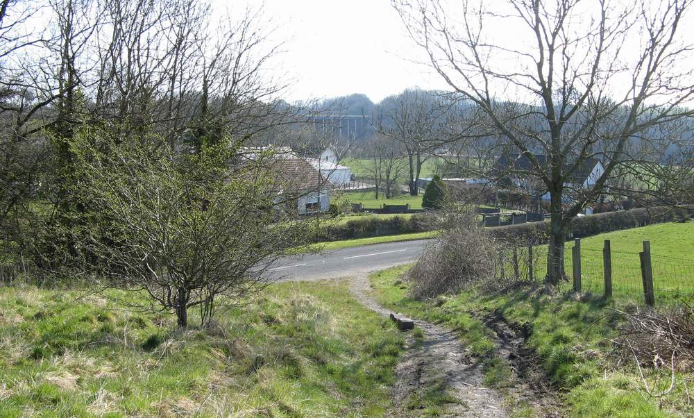
Burnbrae in 2008
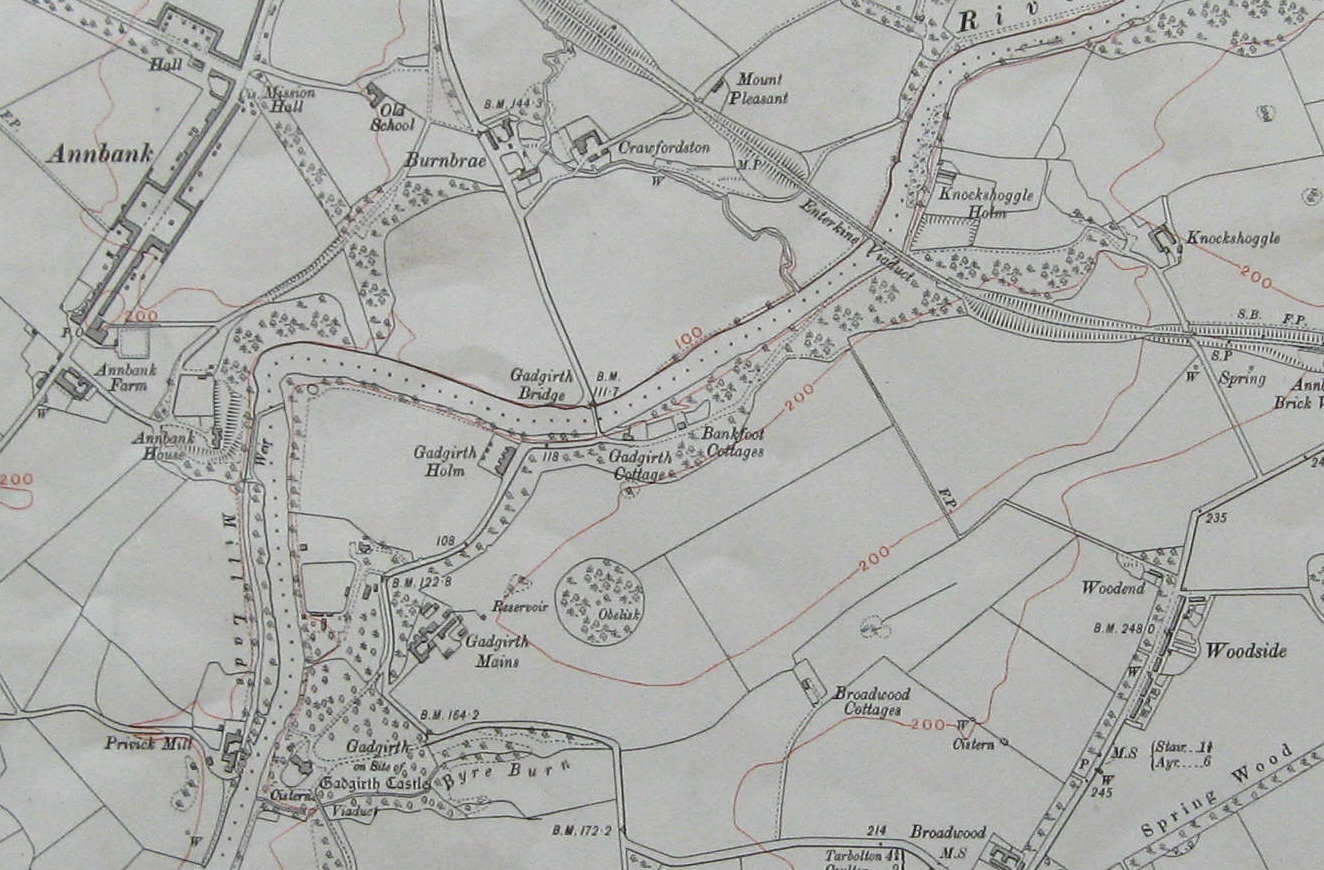
Map of 1911, showing Burnbrae and Woodside
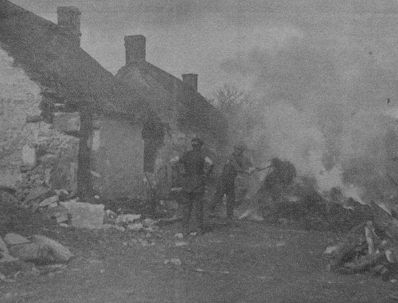
Burnbrae burning, December 1928
Wee Row, Tarholm
The photographs of Burnbrae in 1901 and Wee Row, Tarholm have come from Denholm T Reid, Old Annbank and Mossblown, Stenlake Publishing Ltd, 2005, and are used with the permission of the publishers.
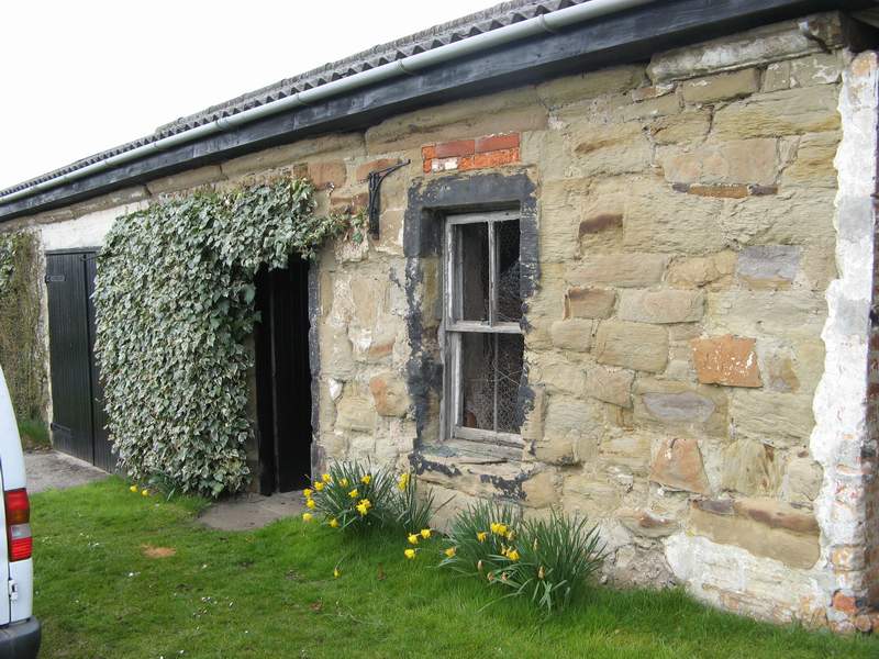
The two remaining houses at Craighall
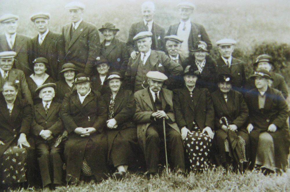
Some of the residents of Tarholm and Craighall
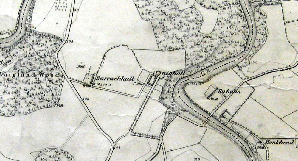
Map of 1911, showing Craighall and Tarholm